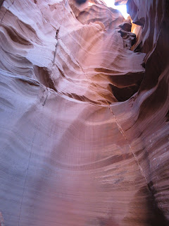
Antelope Canyon X and more Glen Canyon Dam -- September 13, 2023
I pre-booked us the Antelope Canyon X tour. There are also Upper and Lower Antelope Canyons; these are more established and known for being very crowded now. So, we wanted to try Canyon X to hopefully have fewer other people. The different slot canyon areas of Antelope Canyon are owned by different Navajo families. We met at their office by check in time; when it was time to go, they brought around and loaded assigned vans. Then it was a long drive on a dirt road to the canyons. There was either stairs or a trail down to the two slot canyons that we visited. We went in and out of each canyon. Beautiful sandstone slot canyons! The second picture is part of the X that the canyon is named for. People in this area liked to name things for what they look like. Our tour guide, Van, was awesome. He pointed out flood lines (the hurricane that came in at LA brought some flooding) and things that you can see in the rocks. He did a panorama picture on each group on one of their phones, but ours did not look good.
The jacuzzi, water that drips into the canyon into a pool.
Van demonstrated how Navajo sandstone was formed and split to form slot canyons.
After looking at the other options in town, we opted for Paco Tacos again. Travis regretted not getting a the drink called horchata, and I wanted the quesadillas again. Today, the dining area was closed with only the drive-in open, so we ordered and went to a park nearby. The park was near a high school with open campus lunch, so kids kept trickling in to have their lunches. Only tables in the sun were left when we arrived, so it was hot. The kids found shade by sitting on the grass. The food was not as good as day one. Travis liked the drink though, but I was not a fan.
Then we drove to Utah to hike Bucktank Draw and Birthday Arch still in Glen Canyon park. We had the trailhead marked on Google maps and kept passing it. We found a place that was reasonable to park, and then could not find a trailhead. A picture of the lake from the drive, and this is the rock with a window near the parking spot.


Using Travis's map and GPS, we finally found the way to the trail, which was a dry wash. On the hike, we were going to arches. Here is the first arch:
We found the trail and headed toward the next and main arch, Birthday Arch. There was some rock climbing/scrambling required. Dark clouds were coming in, and we were keeping an eye on them. Before making it to Birthday Arch, we decided that we better turn around due to the approaching storm. We stayed on the wash, but going in the other direction. We found the gate where the trail was really supposed to start, which lacked a parking lot, making it hard to find speeding by on a highway. Then we had to walk along grass along the road back to our car. This was scary; there were big drainage crevices that one had to hop or climb down and out...terrifying. I got stuck in one and was scared. We made it back to the car at the not really trailhead; we also left the windows cracked because the sun was out when we started. Yay, we also survived the hike. Travis was disappointed at missing the big Arch. I do not recommend the hike; of course, some of it we did wrong. It is listed as Easy to Moderate with Distance Varies.
On the way back to Arizona, we stopped at the Wahweap boating area; this is the only area of Glen Canyon (that we visited) that costs or required the Annual Pass to get in. There are many other areas of Glen Canyon that one could visit. We got some good Lake Powell shots.
The dam was visible from the lake area.


Then we went back to the Carl Hayden Visitor Center, while it was not raining; we walked across the bridge. The power collection on the other side of the bridge, we did not know what the boats were for, also on the other side of the bridge, the dam and power generation, and dam and bridge. The bridge was fenced with camera slots for pictures.
For our last hike, we went to The Chains, described also as Easy to Moderate and Distance Varies. This trail is also near to the Visitor Center, across the bridge; it was a dirt road off of the parking area for the Hanging Gardens trail. There was not a trail, but rock that went down toward the Colorado river before it was stopped by the dam. It was pretty terrain and the river was nice along the banks.
Travis way down there, and the dam at our level. However, on the way back up, Travis make me scale a hill, which was terrifying. (Now that I'm older now; most things are terrifying.)
We had one more night at the Motel 6, and heading back toward home tomorrow, eastbound.


Comments
Post a Comment